Showing posts with label India. Show all posts

Thursday, June 11, 2026

Upper Pindar, Multiday Fun In Uttarakhand, India

Kayaker on edge, orange rock, and lots of whitewater
Damin Singh getting his lean on the Upper Pindar


Put In:          GPS (30°06'07.2"N 79°54'57.7"E) Note: small bridge
Take Out:     GPS (30°01'16.5"N 79°40'46.3”E) Note: new bridge not on map yet
Class:           Day One class 3-4, day Two class 5, day Three class 4 

big rolling green hills framing snow capped peaks in the background
Mount Nanda Devi

Description:

The Pindar River flows from the glacial expanse on the southern escarpment of the Nanda Devi Mountain (25,643 feet) the second-tallest peak in India. A full-day drive on fairly good roads (for India) brought us (Arjun Sagoi, Daman Sing, Georgia Farmer, and myself, Chris Baer) to a pass with a significantly worse road and spectacular Himalayan views. Up and over the pass we went into the Pindar Valley and to the tiny village of Khati. We stayed in the loft of a local merchant, who made us a nice breakfast the following morning. The hospitality of the mountain folks is genuine, giving. 

kayaker in lots of whitewater sliding between orange rocks
Arjun Sagoi sliding into the Upper Pindar

Day one

Arriving at the put-in bridge, we were joined by a portion of the town that was very inquisitive about our whitewater costumes and our ability to shove all of our multiday equipment into the stern of our kayaks. Once the population of Khati was satisfied with group photos and words of warning, we put on. 

women in authentic local robes watching kayakers prepare for mission
locals of Khati looking on as we prepare our equipment

This first section is relatively mellow; most of the river meanders through a beautiful, dense forest, with massive trees that occasionally canopy the entire river. The whitewater is mainly class 3 with one or two class 4 moves. We traveled five miles to our riverside camp (30°05'48.2"N 79°51'15.2"E) under a bridge, and just outside of the village of Dhaula. I certainly wouldn’t say this was my favorite camp. The bridge looked to be in an ever-evolving state of disrepair and clattered loudly with every person, donkey, or vehicle that crossed. l awoke the following morning to the clatter of the bridge and chimes of bells. The bells were attached to donkeys (I assume the bells are used to track the donkeys when they invariably wander off into the jungle). The donkeys were being used as beasts of burden to haul sand from the beach for the construction of concrete structures in the neighboring village. 

bright blue water, kayaker mostly underwater,
Arjun Sagoi getting pitted on the Upper Pindar

Day Two 

The river passes through a large sedimentary deposit. We are paddling in the dry season, but during the monsoon season, the river erodes a new path through this soft sedimentary section every year. This means we are paddling between massive boulders; there are siphons and undercuts in every rapid. With the combination of a high noon start and very difficult scouting options, our downstream progress was exhaustingly slow. In four hours, we made it only one mile downstream, spending the majority of our time scrambling over massive boulders in the attempt to get a limited peek at the next horizon line. We managed to paddle all but one rapid in this difficult and dangerous sedimentary section. We set camp amongst the giant boulders with one last significant rapid to paddle in the morning. We quickly started to refer to this last rapid as Breakfast Rapid, as we would get to enjoy it the following morning.

green kayak sliding down bright blue water
Damin Singh putting together one of the longer and relatively sketchy rapids


kayaker paddling between sieves on blue water
Damin Singh finding his route amongst the sieves 

Day Three

Breakfast Rapid deserved a solid scout; thankfully, it paddled fairly well and was a great way to end this boulder-laden section. The river then mellows in difficulty, but not in scenery. Deep rocky gorges with sheer cliffs and fun class 4 rapids are in store. Some of these rapids are fairly hard to scout, and the rock structure continues to be fairly undercut. After five-ish miles of beautiful canyons, the river starts to open. We found ourselves in shallow glacial deposits, where the river would shoal out. These shoals are not fun. There is a new bridge that would make a good take out option GPS (30°01'42.4"N 79°44'50.3”E). Our shuttle logistics got a bit mixed up, and we made our way down a total of 13 miles on day three to yet another new bridge. The crew was all a bit cold and excited for dry clothes and a good meal.

green kayak nose in the air scooting away from waterfall
Damin Singhwith a pretty wheelie on the last ledge of Breakfast Rapid 


Chris Baer looking smug
adventure by Chris Baer

Saturday, May 30, 2026

Alakananda River, Uttarakhand, India

Canyon section of the Alakananda River


Put In:            GPS (30°29'48.2"N 79°28'37.4"E) Note: upstream, river left of bridge, steep slope
Take Out:       GPS (30°24'28.7"N 79°23'13.9"E) Note: confluence with Birahi Ganga
Class:             3-4 with one burly class 5 landslide rapid 

Description:

                      Initially, we attempted to gain access to the canyon via a hydroelectric scheme that is located upstream of our eventual put-in location. This upstream access would have allowed us to gain a few more rapids. Unfortunately, we were turned away by the workers. I do believe this access could be granted, but it will definitely take some shmoozing of multiple groups; none of the employees seemed willing to say yes outright. 

kayaker amongst huge boulders and blue water,
Varun Kamath in the depths of the Put In Rapid 

Arriving at the foot bridge, a quick scout revealed access downstream and on river right, or upstream river left, over the hill, and with a steep embankment to the water’s edge. The upstream access, although a little more tedious, allows for another fun rapid.

green kayak, big whitewater, house size boulders
Damin Singh maneuvering around house size boulders

There is essentially no warm-up for the first rapid, and scouting is difficult because the main line is on the far side of the river and obscured by a house-sized boulder. Thankfully, the main line is wider and paddles smoother than it looks. 

blue river with massive mountains on either side and snow capped peaks in the background
committing canyon down there

After the first rapid, you will find yourself in a fairly deep and steep canyon with some relatively boily and pushy whitewater, mostly grade 4. 

fluffy whitwater with big rocks small blue pyranha kayak
Manish Singh Rawat, weaving through the landslide rapid

After a handful of slightly more open rapids, you will notice a massive landslide on river left. This landslide has created a fairly nasty rapid, with large portions of the flow going into multiple siphons. Manish and Daman both fired up the entrance to this rapid, but then portaged the bottom that disappears under some massive boulders. There is also a portage “trail” on the river left; the “trail” is on landslide rock, be careful!

itty bitty kayakers below a waterfall raining into river
waterfalls cascading down into the Alakananda River

After the landslide section, the river really starts to shine. The river is tucked into a very tight and containing canyon with waterfalls cascading down. The rock strucer itself is stunning with wild striations and exquisite formations. There is also a bunch of fun class 3-4 rapids. 

striated gorge beautful rock canyon with jungle above
Georgia Farmer and team, the Striated Gorge
 

Devastatingly this section has yet another dam being built on it, and will probably have a large portion of it dewatered soon. 


Birahi section of the Alakananda River


Put In:            GPS (30°24'28.7"N 79°23'13.9"E) Note: confluence with Birahi Ganga
Take Out:       GPS (30°19'54.4"N 79°18'52.7"E) Note: confluence with Nandakini 
Class:             3 with a couple of easy class 4

Description:    

                      A great section to warm up on, which allows you to get acquainted with the volume and style of the Alakananda River. 

old lady working a loom
An ederly lady weaving fabric on a loom in the Nandyprayag Women's Center 


Nandprayag section of the Alakananda River


Put In:            GPS (30°19'54.4"N 79°18'52.7"E) Note: confluence with Nandakini 
Take Out:       GPS (30°15'45.4"N 79°12'45.7"E) Note: confluence with Pindar
Class:             3-4

Description:    

                      This section starts and ends with a couple of bigger confluence rapids and is interspaced with some epic views and the occasional big water boof.


Women of Nandprayag laughing and playing in kayaks
Huge smiles on the ladies of Nandprayag, as the playing with our kayaks


Karnaprayag section of the Alakananda

green kayak wheelie through grey whitewater and big rocks
Damin Singh gettind a big wheelie


Put In:            GPS (30°15'45.4"N 79°12'45.7"E) Note: confluence with Pindar River
Take Out:       GPS (30°17'46.9"N 79°04'14.7”E) Note: Shivanandi
Class:             3-4

Description:

                      Two fun class 4 rapids, tons of rolling waves, water volume is getting big. 


Lower Canyon of the Alakananda 


Put In:            GPS (30°17'46.9"N 79°04'14.7”E) Note: Shivanandi
Take Out:       GPS (30°17'14.4"N 78°59'01.6”E) Note: Rudraprayag
Class:             3


Description:

                      Mellow class 3, could be a good teaching section, which goes through one tight canyon that is really pretty, and surprisingly easy.


Chris Baer smirking
adventure by Chris Baer


Wednesday, April 29, 2020

Eddy Lines, another pod cast...

Eddy Lines, another pod cast...


Gregory Cairns gave me a ring the other day, asking me to be on yet another pod cast. Of course I said yes, it's not like my schedule is packed during these quarantine days. A few unique questions in there and a great conversation.


The article about the Siang/Brahmaputra river we chat can be found here.


Friday, February 24, 2017

Biggest Class 3 in the World? Siang River, Arunachal Pradesh, India
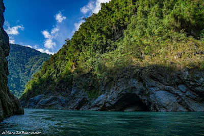
Biggest Class 3 in the World? Siang River, Arunachal Pradesh, India


Colin Aitken looking microscopic on the Siang River, himilayas India, WhereIsBaer.com Chris Baer, huge river whitewater kayak
Colin Aitken looking microscopic on the Siang River

The small jet was making its final approach into Katmandu International Airport. I knew we were close to the ground with wing flaps wide open and the slight feel of falling, but I still couldn’t see the ground. It wasn’t until we were less than hundred feet off the tarmac that I could see through the smog. While collecting my baggage, I was overrun by some of my worst fears of traveling in huge cities: rudeness, pollution, trash everywhere, horns constantly honking, and haggling for everything. After an hour of haggling at the airport, I found transportation to a dingy hotel, with non-locking doors, a cold shower, and plenty of rodent roommates. Fortunately it was just for a night, and I was able to fly out the next day, this time landing in Guwahati and somewhat more reasonable international chaos.

just a random intersection in India , chaotic motor cycles road india, WhereIsBaer.com Chris Baer
just a random intersection in India

The Assam region isn’t part of most people’s mental map of India. Its location and indigenous culture create a beautiful landscape reminding me more of Northern Myanmar than the hustle and bustle of Delhi. Colin Aitken and I had a few mutual acquaintances and were both looking for an opportunity to explore via kayak. We shook hands for the first time in a bus station in eastern India, exchanged pleasantries, and bought tickets to make our way to Pasighat. The bus ride was overnight, close to 16 hours of bouncing through the far Indian wild (east). The view out of the bus window of the countryside was of beautiful, distant rolling hills that fed into the Himalayas. Occasionally the bus would come to a stop and all of the occupants would file out and into what I could only describe as an Indian truck stop. I still can't believe I didn't get food poisoning during this leg of the trip.
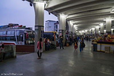


kayaks loaded, not ready for 16 hours of bus travel, traveling with kayaks on busses in india painted bus india bus stop kayak zet whitewater WhereIsBaer.com himalayas, Chris Baer
kayaks loaded, not ready for 16 hours of bus travel

Arriving in the small, jump-off town of Pasighat meant that the chaotic pace of the big city was behind us. While sipping Assam tea we chatted with locals about the logistical challenge of getting our boats to the town of Tuting. Our local advice had us arranging a two day, jarring jeep ride north to the border town. It was seven hours up the watershed to the midway point and the mountain town of Yingkiong. There we chatted with yet more drivers about getting our equipment further up the drainage. With our limited local language skills, we attempted to schedule for a driver to meet us at our hotel the following morning. Seven in the morning came early as we waited outside our prayer flag-adorned hotel. We watched a handful of taxis and tuk-tuks rallying by, but to where? We started asking questions and determined that we ought to catch a taxi to destination unknown… hopefully where the jeep was awaiting. The microscopic taxi, with our two multi-day laden kayaks on top, bounced and bottomed out on our way to a partially completed bridge. Here, the driver gave us the international hand signal of, “Get out and walk across the bridge.”

Colin Aitken waiting outside our luxury amenities for transportation that would never arrive, Arunachal pradesh, Siang river prayer flags block street himalayas WhereIsBaer.com Chris Baer
Colin Aitken waiting outside our luxury amenities for transportation that would never arrive


Colin, damn that bridge is sketchy, bridge wire broken fog river Arunachal Pradesh india himalayas, kayaking kayak cold morning WhereIsBaer.com Chris Baer
Colin, damn that bridge is sketchy

It may have been that I hadn’t had my morning allotment of caffeine yet, but the bridge was sketchy and I wasn’t really feeling it. I’m pretty sure it was erected mostly with driftwood and bailing wire. There were missing boards everywhere, and it swayed with the lightest breeze. To top it off, the early morning fog was thick and you couldn’t tell how long, or for that matter how high up, the bridge was. Then I had the unnerving thought that I alone might be the heaviest thing that the bridge had transported in quite some time, not to mention I was shouldering my loaded down creek boat.

We scurried across the bridge and walked up the steep embankment on the other side to see a myriad of loaded down jeeps. Their drivers were attaching bags and pots onto the roofs of the vehicles. We were quickly greeted and given another hand signal, “Tie your boats down, we are about to go!” Still unsure if this was exactly the ride we had paid for, but not caring so long as we had a ride, we helped tie our kayaks to the roof and crammed ourselves inside with seven other passengers. We bounced another seven hours up the valley. Arriving in Tuting late in the afternoon on December 30th, Colin and I were exhausted from the travel and wanted to enjoy the labor of our work. We decided to spend New Year’s Eve in Tuting, which allowed me to capture some photo/video clips and explore the uniquely located mountain town. January 1st, we awoke to a partly cloudy sky, and we wandered down to the massive blue-green river. The hike in gave us a good vantage of the first rapid, it looked like it was going to be big. Trying to get comfortable in massive volume water, I paddled out to the main current and felt what seemed like ocean waves coming at me from every angle.
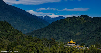
Buddhist monastery outside of Tuting, Arunachal Pradesh India Himalayas, kayaking WhereIsBaer.com  Chris Baer
Buddhist monastery outside of Tuting
Tuting, Siang River, the beginning prayer flags wind blowing huge river whitewater waves distance valley mountains arunachal pradesh india himalayas kayak WhereIsBaer.com Chris Baer
Tuting, Siang River, the beginning

The first day on the river produced by far the best whitewater of the section, including two utterly massive rapids. The first was caused by the delta of a tributary entering on the right forcing 100,000 cfs into a huge bedrock wall on the left. The water surged upward into a handful of fifteen-plus foot tall crashing waves. Coming over the first lead-in wave, I finally grasped how huge the rapid was. I was quickly entrenched in the pit of the wave and all I could see was water. The second enormous rapid was again caused by a tributary coming in on the right, but this time, instead of compression waves, it had scattered, house-sized boulders throughout the riverbed making a variety of features to avoid, and a couple of Himalayan-sized waves to blast over. The whitewater stayed world class throughout the entire day. With huge smiles, we pulled over on river left at about five o’clock in the evening to set up camp.

river kayaking tributarty siang river arunachal Pradesh Himalayas, kayak fire locals, WhereIsBaer.com Chris Baer
feeling small in India
camping side of river Arunachal Pradesh kayak himalayas Siang river WhereIsBaer.com Chris Baer
our kitchen, night one

Awaking on the second morning to no sun, my tarp was drenched with dew and the temperature was just shy of cold. Knitted beanie and puffy jacket on, I made a delicious breakfast of oats and Nescafe. On the water, we were greeted with more giant features and a couple of intense river directional changes. While a 90° turn of the river usually isn’t scary, when there is 100,000 cfs smashing into a cliff and creating enormous swirling whirlpools, things start to get entertaining. Mid-afternoon on day two, we passed under the sketchy Yingkiong bridge which we had crossed on foot in fog only a few days before. We continued downstream through one more splashy wave train and then eddied out on river left so we could hike up to town, where we were excited to find a filling meal and an okay bed to sleep in.

evening view from Yingkiong, india arunachal Pradesh kayak river Siang, himalayas WhereIsBaer.com Chris Baer
evening view from Yingkiong

The roosters were crowing as we awoke in Yingkiong on the morning of day three. The very accommodating hotel owner was already up, and quietly sang to herself in a monk-like, chanting style as she made us a hardy breakfast. The rapids were slightly subdued compared to the previous days, and we were able to cover some substantial mileage. By mid-afternoon we had stopped for a good camp location just upstream of the town of Boleng, allowing us to gather firewood and the chance to set up tarps before the sun set and the thick dew set in.

Chris Baer disheveled tired steripen kayak india himalayas Siang River tuting
Chris Baer, disheveled, exhausted, and thirsty
camoing side of river big agnes tarp kayak whitewater sand beach sun set Siang River Himalayas Arunachal Pradesh WhereIsBaer.com Chris Baer
camp, night three
Colin Aitken, looking small on the Siang River, kayak green river huge rock formation Arunachal pradesh India Himalayas, Siang River, WhereIsBaer.com Chris Baer
Colin Aitken, looking small on the Siang River

Extra-heavy dew and thick clouds awaited us on the fourth morning. We took our time getting off the beach, trying to let the obscured sun dry our sleeping bags and tarps. When it was time to get on the river, we started out strong, paddling a handful of good rapids and then some long pools, and then some more long pools until finally we hit the confluence with yet another substantial tributary, the Yamne River. We were now on multiple hundreds of thousands of cfs. Random boils and massive whirlpools would erupt out of nowhere. It felt more like the ocean than a river. We pushed on, skipping lunch and eating a quick snack while in our kayaks. We paddled and paddled. My hands and shoulders were sore and the sun was starting to set. From everything we had gathered, we shouldn’t have been too far from Pasighat, so we paddled on. By the time we got a glimpse of the Pasighat bridge, it wasn’t so much that I could make out that it was a bridge than there were levitating headlights in the distance.

colorful food at market vegetables india Arunachal Pradesh Himalayas Siang River, WhereIsBaer.com Chris Baer
local market

Climbing out of our kayaks after a solid eight hours of paddling was painful. We sluggishly carried them up to the bridge and hitchhiked into town. Luckily, kayakers are an extreme oddity in these parts and a few young men getting off their shift, with smiles and multiple handshakes, quickly picked us up and drove us into downtown. We eagerly, hungrily, hopped out of the truck and made our way to our favorite hole in the wall eatery. With a solid meal in us we wandered back to our local accommodations, blowing off return logistics until morning.


WhereisBaer.com river blue india Siang river kayak himalayas Arunachal Pradesh Siang river
adventure by Chris Baer