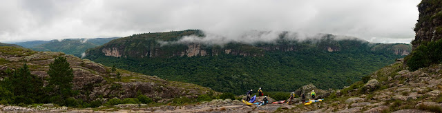
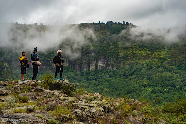
Showing posts with label Baer. Show all posts

Wednesday, October 19, 2022

Heavy Rains in Brazil

Rio Santa Maria

Put In:    GPS (-27.0484929,-49.0920952)    Note: Information center and Gate

Take Out:     Note: As far down as you want to go

Class:    4-5 Flow dependent

Flow:    Visual, needs some rain

Description:    Located in the National Park of Serra do Itajaí just outside of the fairly large city of Blumenau. The common light afternoon rain showers make this section flow very consistently. Lower flow days make for a user friendly drop pool style run that is very manageable. With high flows, after a heavy rain, everything starts to link and becomes continuous; a local guide is stronly recommended for these higher flow days. 
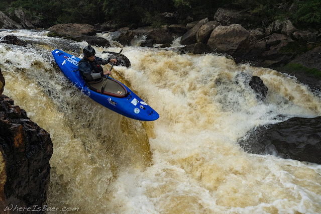
 

Rio Forcaçāo

Put In:    GPS (-26.7327393,-49.5350614)    Note: Park and huck, multiple falls

Class:    5

Flow:    Visual, requires heavy rain

Description:    Park and huck options. The upper portion of this river has a tendency to create some fun waterfalls and slides. 
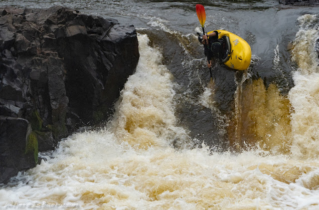
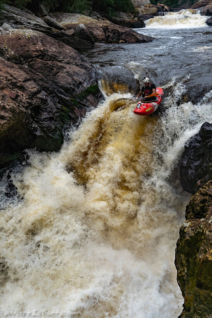

Caí River

Put In:    GPS (-29.269822, -50.754375)    Note: Hydro Dam    

Take Out:    GPS (-29.292196, -50.910232)    Note: First bridge crossing

Class:    5

Flow:    Visual, requires medium rain, entirely dam dependent

Description:    Put in is at a hydroelectric dam, so you need a bit of good luck and rain for it to run. Dam personnel seemed very ok with us being on the property; they even gave us a ride down the hill to the water. The section is 30+ km long, so bring a snack. Rock structue looks newer and volcanic, making it relatively sharp with tons of undercuts and sieves. The location is beautiful with huge towering rock formations whose huge walls also make this river very committing and pretty darn remote.  


Rio Cubatáo

Put In:    GPS (-27.711267, -48.852276)     Note: Small bridge   

Take Out:     GPS (-27.691320, -48.777066)    Note: Side of road

Class:    4-5, flow dependent

Flow:    Visual, requires light to heavy rain

Description:    There are two separate sections here: above and below the conflence near the city of Águas Mornas. Above the city, it feels fairly creeky with a handful of step rapids and one suggested portage. Below, it gets more water and has a full river feel with low angle slides.  


Cachoeira do Zimbira

Put In:    GPS (-27.647800, -48.863942)    Note: Tiny bridge, water should be flowing over some of it    

Take Out:    GPS (-27.664355, -48.855999)    Note: Side of road as you exit jungle

Class:    5

Flow:    Visual, requires heavy rain

Description:    This micro creek needs a ton of rain, so expect to encounter numerous down trees. Rapids come in quick succession with the ability to scout being massively hindered by the very dense jugle vegetation. A local guide is almost a necessity. The big drop is 20+ feet tall with a very deceptive lead-in and lip; scouting from river right is recommended. 

Saturday, April 9, 2022

Rio Iapo and Tibaji, Brazil

Stunning views for the mile-ish hike in

Rio Iapo 

Put In:    GPS (-24.631704, -50.210583) Note: Hike in through farm land, down hill, and upstream.

Take Out:    GPS (-24.504276, -50.327558) Note: Private property? Bouncy dirt road.

Class:    4 (2 class 5 rapids, or easy portages on left) 

Flow:    Visual, has flow for longer into the season, large drainage.

Discription: This section is a solid day trip from most other paddling locations, but it's worth it. A relatively large watershed holds water late into the year. Mostly a class 4 section with two notable class 5 rapids, both are easily scouted or portaged river Left. Large Rock outcroppings at the put in are gorgeous.


Rio Iapo and Rio Tibaji Brazil from Chris Baer on Vimeo.


low lying clouds give scale to the valley

showing the gradient on the hike in

Joao Garbriel Araujo, getting his lean on

the first class 5, undercut landing zone on the left

one of the abundent class 4 ledges

Rio Tibaji 

Put In:    GPS (-24.469234, -50.476162)

Class:    4

Flow:    Visual, always has flow.

Discription:     Park and huck. Wide river section that will almost always have flow and an acceptable line. We ran it on the main flow, river right. Great camping options just upstream on river left.


signifigantly more water on the Tibaji

Thursday, November 2, 2017

Going back to the Youghiogheny

Youghiogheny

 
Sixteen years ago I hopped into a convertible with a few other raft guides for a day trip to a river a few hours north of the Gauley. The location was the magical Upper Youghiogheny. The slots were plentiful and tight, and while playing follow the leader we rounded countless blind corners interspaced with a myriad of fun ledges. Years later, I now refer to this section as a staple class 4 kayak run… that has drawn me back year after year.


So the question is, why? After paddling all over the globe and tons of extremely difficult sections, why do I, and why should you, continue to flock to the Upper Youghiogheny?

Let’s start with the location. Our take out is in Friendsville, Maryland, almost reason enough right there. Friendsville is home to pizza rolls, Maui sweet onion potato chips, and fancy Yuengling beer. It used to be home to one of my favorite restaurants anywhere, The Riverside Hotel. Agnes, the proprietor of the Riverside Hotel and Restaurant, concocted the best vegetarian food I could conceive. It was simple, they only served vegetarian soup and salad (Casey Tango had to twist my arm to try this place the first time (I was complaining,“But there’s no meat!”)). After the first bite I was a believer. Hardy soups, hot-from-the-oven blue corn muffins, edible flowers on the salad (that were picked out of the backyard garden while you were paddling on the river), Tandy Cake with home-churned ice cream for dessert. (Please Agnes come back and make us delicious food again! (the Riverside Hotel changed ownership in 2015, and again in 2017. No food now, almost a reason not to go…)).

Camping is free-ish and only ten minutes from the put-in. The dense forest of the campground reminds me of the woods from the Blair Witch movie. Over the years there have been some pretty epic parties that have occurred in these Blair Witch woods. Huge bonfires, tons of fireworks, friends from all over the world. Heck, there was the one year when some riggers showed up and constructed a 100 foot rope swing attached to the tippy tops of the surrounding trees.

During my first years to the Youghiogheny there always seemed to be a rumor in the air. The reservoir was too high, it was too low, the release was late, the flows were going to be HIGH, not enough water, were we in front of, or behind, the bubble? National Falls is on fire?! I don’t know why but the rumors always made me laugh and we almost always were perfectly on the bubble with an average flow.

On water the river seems to be very reciprocal. If you’re willing to put the effort in you can run some truly hard lines. It’s like the river almost wants you to play. There are hanging eddies everywhere, slots that shouldn’t go (Sid’s Squiggle, Time Warp, left left at Tommy’s), and a couple of communal stops to enjoy some bag wine with the river community (Wait Rock and National Falls). 

So, what brings you back to the Yough year after year after year… and if you haven’t checked this place out, why not??

adventure by Chris Baer


Thursday, January 19, 2017

Feeling Small in Nepal, Upper Marsyangdi

Feeling Small in Nepal, Upper Marsyangdi


Looking north into the tallest mountains in the world, nepal, himilayan mountains snow capped peaks river Upper Marsyangdi, river kayak whitewater, WhereIsBaer.com Chris Baer
Looking north into the tallest mountains in the world

The tallest mountains in the world surround us. Their brilliant, snow-encrusted peaks seem almost dull in comparison to the vibrant prayer flags and audaciously painted structures here in the quintessential Himalayan mountain town of Jagat. From this microscopic Nepali village, Garen Stephens and myself would start yet another trip of a lifetime. The plan was simple; kayak from just north of Jagat nineteen miles down to the slack water of the Mid-Marsyangdi hydro-dam, located just to the south of the town of Besisahar.

the $10 a night hotel in Jagat had a view, Upper Marsangdi river nepal himalayas mountains valley snow caped WhereIsBaer.com Chris Baer
the $10 a night hotel in Jagat had a view


Finding Poise in International Logistics


Just under a week before arriving in Jagat, I was meeting up with Kate Stepan and Justin Kleberg in Pokhara, Nepal. We were hashing out plans for what seemed like a fairly straightforward mission… But international logistics always seem to have a dozen wrenches in them; it’s just a matter of trying to determine where they might pop up, and how to deal with them as smoothly as possible when they do. It might be that the vehicle breaks down, it might be that your language skills fail you and you end up in a town hours away from your destination, it might be that the boats don’t fit, or they get denied, or there is sharp metal that will wear through your boat on the roof rack. Or it might be that your attempt at local haggling doesn’t work in your favor, or you get food poisoning from what looked like delicious street food, or the fact that nothing is on schedule and arriving three hours late is standard. Trying to combine what seem to be simple logistics almost never works internationally, but when it does it feels almost magical.

loading kayaks for the trip to Besisahar, bus kayak mountains himalayas snow WhereIsBaer.com Chris Baer
loading kayaks for the trip to Besisahar


bus overcrowded nepal, WhereIsBaer.com Chris Baer mirror
this bus isn't even close to full


Upper Marsyangdi, kayak city bus whitewater, WhereIsBaer.com Chris Baer
arriving in Besisahar


kid in kayak in nepal, prayer flags, child cute, Upper Marsyangdi Himalayas WhereIsBaer.com Chris Baer
local greeting committee

This first leg of the trip, we actually pulled it off: our tourist bus (has less chickens on it, and you usually get a seat) left Pokhara almost on time, it didn’t break down or get in an accident, and we arrived in Besisahar at about noon. Upon arrival, the team broke into different roles: watching the equipment, looking for a room, and searching for a jeep. With the tasks completed, we reconvened and walked to the “hotel”, tossed our bags into the room, dug out our paddling equipment, then walked back across the street to our awaiting jeep. We quickly piled boats and ourselves into the jeep and started to bounce our way up the dirt “road” to Simpani (the border of the Annapurna Conservation area). There we quickly geared up and got on the river. It was a blast! Nearly eight miles of splashy, continuous class 4 water.


annapurna mountain range, Marsyangdi upper, nepal Himalayas, WhereIsBaer.com Chris Baer river whitewater snow capped peaks
looking back on the Annapurna Range

After two days of quintessential class 4, Justin Kleberg and I walked down the street from our hotel to the Annapurna Conservation Area permit office and doled out twenty dollars each to attain our special access permit. This would allow us to travel further up into the drainage. Four more miles up the road, we went to Lamjung and put on at the brink of yet another dam. Subsequently, the section had a portion of its water pulled out and through the hydro scheme. Although the section was partially dewatered, it had a slightly steeper gradient profile then the lower section. It was again spectacular class 4/4+ whitewater. The lines were significantly tighter with more river-wide, dynamic features then the lower section, but thankfully it was entirely boat-scoutable.

Annapurna special access permit, mountains Upper Marsyangdi river whitewater, kayak WhereIsBaer.com Chris Baer
Annapurna special access permit

the lady standing in the aisle just out of frame pawned this chicken-in-a-bag off on these guys, they didn't seem so stoked, overcrowded bus nepal rural mountain WhereIsBaer.com Chris Baer
the lady standing in the aisle just out of frame pawned this chicken-in-a-bag off on these guys, they didn't seem so stoked

The following day Kate and Justin had to leave, so I messaged Garen Stephens. He said he was on his way, and wanted to know if I would stick around for a couple more days. I couldn’t say yes fast enough. The sections that we had paddled so far were classic, and a couple more laps on these gems seemed obligatory. Garen made it to Besisahar the next day around midday, and we rallied up for a quick get-to-know-you lap to make sure we would make good paddling partners. We instantly bonded and agreed it would be an exciting mission to head yet further up into the drainage.


local festivities in Besisahar, ferris wheel with mountains in the background, snow himalayas, nepal WhereIsBaer.com Chris Baer
local festivities in Besisahar


Yet Further Up the Watershed


The jeep ride got sketchier and bouncier as we continued into the upper part of the drainage. A kilometer past Jagat, the road got relatively close to the river and we signaled to the driver to pull over. The Marsyangdi had changed character; it was now walled in and the rapids were stacked on top of each other. This section is relatively steep at 122 feet per mile, and had not been dewatered by a dam making it rather pushy. We could no longer boat scout as safely as we had in the middle section, and found ourselves out of our boats at almost every horizon line. 

one of the dozen or so cable bridges spanning the river, Upper Marsyangdi Nepal Himalayas mountains river cable bridge, whitewater kayak, WhereIsBaer.com Chris Baer
one of the dozen or so cable bridges spanning the river

Vertical Walls and Portaging Are a Trying Combination


We were only a kilometer downstream from the put in when Garen hopped out of his kayak to take a peek at yet another horizon line. This time, he had a different look on his face. There was contemplation, and maybe a bit of concern, as he shouted to me, “you’re going to want to take a peek at this!” The rapid was rather heinous. There was definitely a line, but it looked like one of those rapids that you fired up the day after you broke up with your significant other. Portaging looked almost equally heinous. We were heading into an uncertain black hole with overhanging boulders looming above and a 45 degree slope of slippery rocks coated in dark slime that all angled down towards the massive siphon that was the cause of our hike in the first place. Then there was a cave-like rock structure that we had to shoved our boats through. Then we precariously maneuvered a thin rock ridge thirty feet above yet more siphons. Next up was a small jump across a death crevasse, followed by a steep, overgrown hillside full of thorns. That led quickly into a dry creek bed with plenty of ankle-rolling sized cobble stones, and even more overgrown vegetation. I leaned into the melee of foliage with all my weight but the flora proved unresponsive to gravity.

Garen Stephens, enjoying another classic class 4 rapid, Upper Marsyangdi river blue water kayak rocks WhereIsBaer.com Chris Baer
Garen Stephens, enjoying another classic class 4 rapid


feeling small tucked into the Himalayas, huge mountains, blue river kayak zet director, Upper Marsyangdi nepal himalayas, WhereIsBaer.com Chris Baer
feeling small tucked into the Himalayas


An hour and a half later we made it back onto the water. We were making slow progress. Continuous scouting proved necessary with yet more difficult, stacked rapids that had plenty of no-go locations. Time wasn’t on our side as the sun soon dipped behind the Himalayas. Graciously, the canyon walls momentarily subsided and allowed us an escape from the river. We had made such little downstream progress that we decided to walk the kilometer or so back up to the picturesque village of Jagat, where we enjoyed a relatively soft bed, hot food, and a cold beer.


Garen Stephens heading into the unknown , blue river, upper marsyangdi river, nepal himalayas kayak werner paddles, WhereIsBaer.com Chris Baer
Garen Stephens heading into the unknown


Day Two, Marsyangdi


The early morning light illuminated the ridiculously steep valley as we hiked back down to the river. Our first rapid was rowdy and got us back in the spirit. The river was once again producing amazing whitewater, one great rapid after the next. Thankfully, we were able to boat scout significantly more rapids on the second day. The only portage that we encountered had a marginal line, but we just weren’t feeling it. Late on day two we stumbled upon a hot spring on river left (next time I might plan on camping at this location and enjoying the hot springs into the evening), but we continued down to the village of Lamjung where we spent the night.

put in, day two, blue river with water fall kayak whitewater, Upper Marsyangdi Nepal Himalayas, WhereIsBaer.com Chris Baer
put in, day two


Day three, we routed down the familiar lower section connecting nineteen miles of spectacular class 4, with a couple of bonus big rapids to contend with. If this river were stateside, it would be a true classic, with hordes of paddlers on it every day.

our daily commute tieing kayaks ontop of a bus in nepal himalayas Upper Marsyangdi river whitewater, Nepal, WhereIsBaer.com Chris Baer
our daily commute


Chris Baer, WhereIsbaer.com Upper Marsyangdi river Nepal Himalayas
adventure by Chris Baer